|
osgEarth 2.1.1
|
|
osgEarth 2.1.1
|
#include <osgEarth/GeoData>#include <osgEarth/ImageUtils>#include <osgEarth/Registry>#include <osgEarth/Cube>#include <osg/Notify>#include <osg/Timer>#include <gdal_priv.h>#include <gdalwarper.h>#include <ogr_spatialref.h>#include <memory.h>#include <sstream>#include <iomanip> Include dependency graph for GeoData.cpp:
Go to the source code of this file.
Defines | |
| #define | LC "[GeoData] " |
| #define | LC "[Geoid] " |
Functions | |
| static osg::Image * | createImageFromDataset (GDALDataset *ds) |
| static GDALDataset * | createMemDS (int width, int height, double minX, double minY, double maxX, double maxY, const std::string &projection) |
| static GDALDataset * | createDataSetFromImage (const osg::Image *image, double minX, double minY, double maxX, double maxY, const std::string &projection) |
| static osg::Image * | reprojectImage (osg::Image *srcImage, const std::string srcWKT, double srcMinX, double srcMinY, double srcMaxX, double srcMaxY, const std::string destWKT, double destMinX, double destMinY, double destMaxX, double destMaxY, int width=0, int height=0) |
| static osg::Image * | manualReproject (const osg::Image *image, const GeoExtent &src_extent, const GeoExtent &dest_extent, unsigned int width=0, unsigned int height=0) |
| #define LC "[GeoData] " |
Definition at line 1130 of file GeoData.cpp.
| #define LC "[Geoid] " |
Definition at line 1130 of file GeoData.cpp.
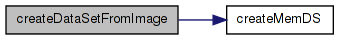
| static GDALDataset* createDataSetFromImage | ( | const osg::Image * | image, |
| double | minX, | ||
| double | minY, | ||
| double | maxX, | ||
| double | maxY, | ||
| const std::string & | projection | ||
| ) | [static] |
Definition at line 660 of file GeoData.cpp.
{
    //Clone the incoming image
    osg::ref_ptr<osg::Image> clonedImage = new osg::Image(*image);

    //Flip the image
    clonedImage->flipVertical();

    GDALDataset* srcDS = createMemDS(image->s(), image->t(), minX, minY, maxX, maxY, projection);

    //Write the image data into the memory dataset
    //If the image is already RGBA, just read all 4 bands in one call
    if (image->getPixelFormat() == GL_RGBA)
    {
        srcDS->RasterIO(GF_Write, 0, 0, clonedImage->s(), clonedImage->t(), (void*)clonedImage->data(), clonedImage->s(), clonedImage->t(), GDT_Byte, 4, NULL, 4, 4 * image->s(), 1);
    }
    else if (image->getPixelFormat() == GL_RGB)
    {
        //OE_NOTICE << "[osgEarth::GeoData] Reprojecting RGB " << std::endl;
        //Read the read, green and blue bands
        srcDS->RasterIO(GF_Write, 0, 0, clonedImage->s(), clonedImage->t(), (void*)clonedImage->data(), clonedImage->s(), clonedImage->t(), GDT_Byte, 3, NULL, 3, 3 * image->s(), 1);

        //Initialize the alpha values to 255.
        unsigned char *alpha = new unsigned char[clonedImage->s() * clonedImage->t()];
        memset(alpha, 255, clonedImage->s() * clonedImage->t());

        GDALRasterBand* alphaBand = srcDS->GetRasterBand(4);
        alphaBand->RasterIO(GF_Write, 0, 0, clonedImage->s(), clonedImage->t(), alpha, clonedImage->s(),clonedImage->t(), GDT_Byte, 0, 0);

        delete[] alpha;
    }
    else
    {
        OE_WARN << LC << "createDataSetFromImage: unsupported pixel format " << std::hex << image->getPixelFormat() << std::endl;
    }
    srcDS->FlushCache();

    return srcDS;
}
Here is the call graph for this function: Here is the caller graph for this function:| static osg::Image* createImageFromDataset | ( | GDALDataset * | ds | ) | [static] |
Definition at line 608 of file GeoData.cpp.
{
    // called internally -- GDAL lock not required

    //Allocate the image
    osg::Image *image = new osg::Image;
    image->allocateImage(ds->GetRasterXSize(), ds->GetRasterYSize(), 1, GL_RGBA, GL_UNSIGNED_BYTE);

    ds->RasterIO(GF_Read, 0, 0, image->s(), image->t(), (void*)image->data(), image->s(), image->t(), GDT_Byte, 4, NULL, 4, 4 * image->s(), 1);
    ds->FlushCache();

    image->flipVertical();

    return image;
}
Here is the caller graph for this function:| static GDALDataset* createMemDS | ( | int | width, |
| int | height, | ||
| double | minX, | ||
| double | minY, | ||
| double | maxX, | ||
| double | maxY, | ||
| const std::string & | projection | ||
| ) | [static] |
Definition at line 625 of file GeoData.cpp.
{
    //Get the MEM driver
    GDALDriver* memDriver = (GDALDriver*)GDALGetDriverByName("MEM");
    if (!memDriver)
    {
        OE_NOTICE << "[osgEarth::GeoData] Could not get MEM driver" << std::endl;
    }

    //Create the in memory dataset.
    GDALDataset* ds = memDriver->Create("", width, height, 4, GDT_Byte, 0);

    //Initialize the color interpretation
    ds->GetRasterBand(1)->SetColorInterpretation(GCI_RedBand);
    ds->GetRasterBand(2)->SetColorInterpretation(GCI_GreenBand);
    ds->GetRasterBand(3)->SetColorInterpretation(GCI_BlueBand);
    ds->GetRasterBand(4)->SetColorInterpretation(GCI_AlphaBand);

    //Initialize the geotransform
    double geotransform[6];
    double x_units_per_pixel = (maxX - minX) / (double)width;
    double y_units_per_pixel = (maxY - minY) / (double)height;
    geotransform[0] = minX;
    geotransform[1] = x_units_per_pixel;
    geotransform[2] = 0;
    geotransform[3] = maxY;
    geotransform[4] = 0;
    geotransform[5] = -y_units_per_pixel;
    ds->SetGeoTransform(geotransform);
    ds->SetProjection(projection.c_str());

    return ds;
}
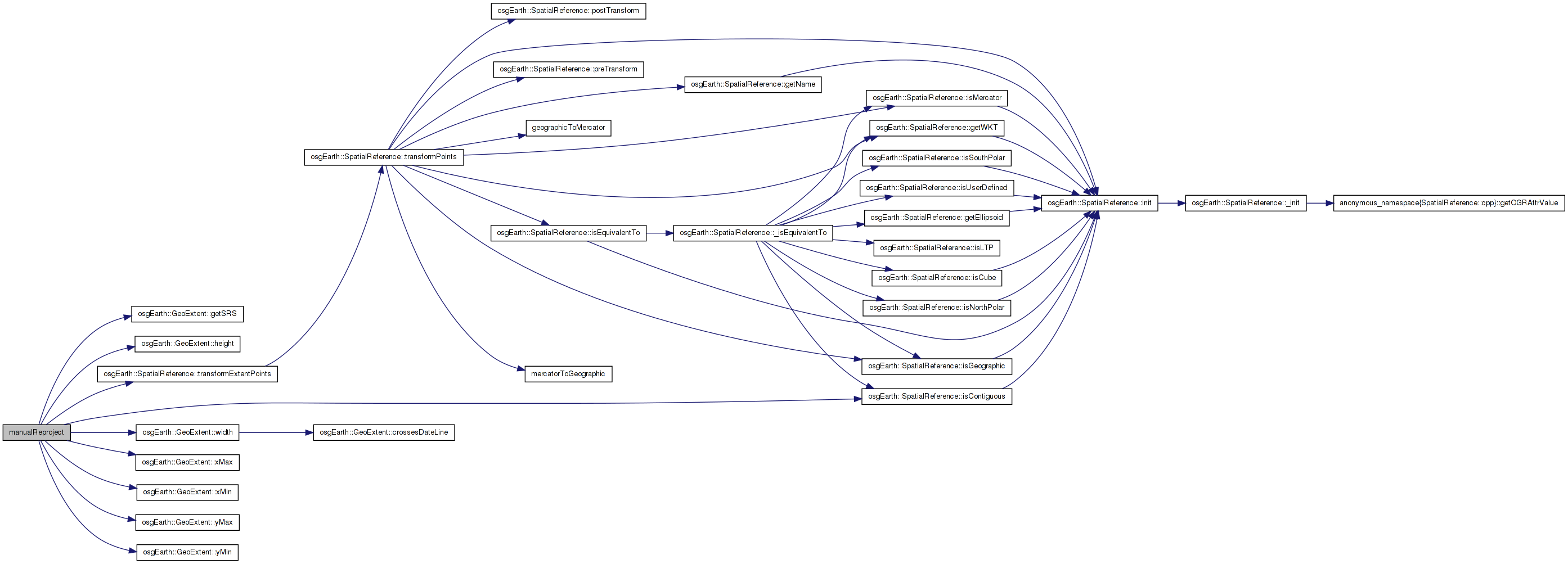
Here is the caller graph for this function:| static osg::Image* manualReproject | ( | const osg::Image * | image, |
| const GeoExtent & | src_extent, | ||
| const GeoExtent & | dest_extent, | ||
| unsigned int | width = 0, |
||
| unsigned int | height = 0 |
||
| ) | [static] |
Definition at line 752 of file GeoData.cpp.
{
    //TODO:  Compute the optimal destination size
    if (width == 0 || height == 0)
    {
        //If no width and height are specified, just use the minimum dimension for the image
        width = osg::minimum(image->s(), image->t());
        height = osg::minimum(image->s(), image->t());
    }

    // need to know this in order to choose the right interpolation algorithm
    const bool isSrcContiguous = src_extent.getSRS()->isContiguous();

    osg::Image *result = new osg::Image();
    result->allocateImage(width, height, 1, GL_RGBA, GL_UNSIGNED_BYTE);
    //Initialize the image to be completely transparent
    memset(result->data(), 0, result->getImageSizeInBytes());

    ImageUtils::PixelReader ra(result);
    const double dx = dest_extent.width() / (double)width;
    const double dy = dest_extent.height() / (double)height;

    // offset the sample points by 1/2 a pixel so we are sampling "pixel center".
    // (This is especially useful in the UnifiedCubeProfile since it nullifes the chances for
    // edge ambiguity.)

    unsigned int numPixels = width * height;

    // Start by creating a sample grid over the destination
    // extent. These will be the source coordinates. Then, reproject
    // the sample grid into the source coordinate system.
    double *srcPointsX = new double[numPixels * 2];
    double *srcPointsY = srcPointsX + numPixels;
    dest_extent.getSRS()->transformExtentPoints(
        src_extent.getSRS(),
        dest_extent.xMin() + .5 * dx, dest_extent.yMin() + .5 * dy,
        dest_extent.xMax() - .5 * dx, dest_extent.yMax() - .5 * dy,
        srcPointsX, srcPointsY, width, height, 0, true);

    // Next, go through the source-SRS sample grid, read the color at each point from the source image,
    // and write it to the corresponding pixel in the destination image.
    int pixel = 0;
    ImageUtils::PixelReader ia(image);
    double xfac = (image->s() - 1) / src_extent.width();
    double yfac = (image->t() - 1) / src_extent.height();
    for (unsigned int c = 0; c < width; ++c)
    {
        for (unsigned int r = 0; r < height; ++r)
        {
            double src_x = srcPointsX[pixel];
            double src_y = srcPointsY[pixel];

            if ( src_x < src_extent.xMin() || src_x > src_extent.xMax() || src_y < src_extent.yMin() || src_y > src_extent.yMax() )
            {
                //If the sample point is outside of the bound of the source extent, increment the pixel and keep looping through.
                //OE_WARN << LC << "ERROR: sample point out of bounds: " << src_x << ", " << src_y << std::endl;
                pixel++;
                continue;
            }

            float px = (src_x - src_extent.xMin()) * xfac;
            float py = (src_y - src_extent.yMin()) * yfac;

            int px_i = osg::clampBetween( (int)osg::round(px), 0, image->s()-1 );
            int py_i = osg::clampBetween( (int)osg::round(py), 0, image->t()-1 );

            osg::Vec4 color(0,0,0,0);

            if ( ! isSrcContiguous ) // non-contiguous space- use nearest neighbot
            {
                color = ia(px_i, py_i);
            }

            else // contiguous space - use bilinear sampling
            {
                int rowMin = osg::maximum((int)floor(py), 0);
                int rowMax = osg::maximum(osg::minimum((int)ceil(py), (int)(image->t()-1)), 0);
                int colMin = osg::maximum((int)floor(px), 0);
                int colMax = osg::maximum(osg::minimum((int)ceil(px), (int)(image->s()-1)), 0);

                if (rowMin > rowMax) rowMin = rowMax;
                if (colMin > colMax) colMin = colMax;

                osg::Vec4 urColor = ia(colMax, rowMax);
                osg::Vec4 llColor = ia(colMin, rowMin);
                osg::Vec4 ulColor = ia(colMin, rowMax);
                osg::Vec4 lrColor = ia(colMax, rowMin);

                /*Average Interpolation*/
                /*double x_rem = px - (int)px;
                double y_rem = py - (int)py;

                double w00 = (1.0 - y_rem) * (1.0 - x_rem);
                double w01 = (1.0 - y_rem) * x_rem;
                double w10 = y_rem * (1.0 - x_rem);
                double w11 = y_rem * x_rem;
                double wsum = w00 + w01 + w10 + w11;
                wsum = 1.0/wsum;

                color.r() = (w00 * llColor.r() + w01 * lrColor.r() + w10 * ulColor.r() + w11 * urColor.r()) * wsum;
                color.g() = (w00 * llColor.g() + w01 * lrColor.g() + w10 * ulColor.g() + w11 * urColor.g()) * wsum;
                color.b() = (w00 * llColor.b() + w01 * lrColor.b() + w10 * ulColor.b() + w11 * urColor.b()) * wsum;
                color.a() = (w00 * llColor.a() + w01 * lrColor.a() + w10 * ulColor.a() + w11 * urColor.a()) * wsum;*/

                /*Nearest Neighbor Interpolation*/
                /*if (px_i >= 0 && px_i < image->s() &&
                py_i >= 0 && py_i < image->t())
                {
                //OE_NOTICE << "[osgEarth::GeoData] Sampling pixel " << px << "," << py << std::endl;
                color = ImageUtils::getColor(image, px_i, py_i);
                }
                else
                {
                OE_NOTICE << "[osgEarth::GeoData] Pixel out of range " << px_i << "," << py_i << "  image is " << image->s() << "x" << image->t() << std::endl;
                }*/

                /*Bilinear interpolation*/
                //Check for exact value
                if ((colMax == colMin) && (rowMax == rowMin))
                {
                    //OE_NOTICE << "[osgEarth::GeoData] Exact value" << std::endl;
                    color = ia(px_i, py_i);
                }
                else if (colMax == colMin)
                {
                    //OE_NOTICE << "[osgEarth::GeoData] Vertically" << std::endl;
                    //Linear interpolate vertically
                    for (unsigned int i = 0; i < 4; ++i)
                    {
                        color[i] = ((float)rowMax - py) * llColor[i] + (py - (float)rowMin) * ulColor[i];
                    }
                }
                else if (rowMax == rowMin)
                {
                    //OE_NOTICE << "[osgEarth::GeoData] Horizontally" << std::endl;
                    //Linear interpolate horizontally
                    for (unsigned int i = 0; i < 4; ++i)
                    {
                        color[i] = ((float)colMax - px) * llColor[i] + (px - (float)colMin) * lrColor[i];
                    }
                }
                else
                {
                    //OE_NOTICE << "[osgEarth::GeoData] Bilinear" << std::endl;
                    //Bilinear interpolate
                    float col1 = colMax - px, col2 = px - colMin;
                    float row1 = rowMax - py, row2 = py - rowMin;
                    for (unsigned int i = 0; i < 4; ++i)
                    {
                        float r1 = col1 * llColor[i] + col2 * lrColor[i];
                        float r2 = col1 * ulColor[i] + col2 * urColor[i];

                        //OE_INFO << "r1, r2 = " << r1 << " , " << r2 << std::endl;
                        color[i] = row1 * r1 + row2 * r2;
                    }
                }
            }

            unsigned char* rgba = const_cast<unsigned char*>(ra.data(c,r,0));

            rgba[0] = (unsigned char)(color.r() * 255);
            rgba[1] = (unsigned char)(color.g() * 255);
            rgba[2] = (unsigned char)(color.b() * 255);
            rgba[3] = (unsigned char)(color.a() * 255);

            pixel++;
        }
    }

    delete[] srcPointsX;

    return result;
}
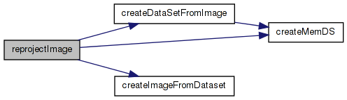
Here is the call graph for this function: Here is the caller graph for this function:| static osg::Image* reprojectImage | ( | osg::Image * | srcImage, |
| const std::string | srcWKT, | ||
| double | srcMinX, | ||
| double | srcMinY, | ||
| double | srcMaxX, | ||
| double | srcMaxY, | ||
| const std::string | destWKT, | ||
| double | destMinX, | ||
| double | destMinY, | ||
| double | destMaxX, | ||
| double | destMaxY, | ||
| int | width = 0, |
||
| int | height = 0 |
||
| ) | [static] |
Definition at line 701 of file GeoData.cpp.
{
    //OE_NOTICE << "Reprojecting..." << std::endl;
    GDAL_SCOPED_LOCK;
        osg::Timer_t start = osg::Timer::instance()->tick();

    //Create a dataset from the source image
    GDALDataset* srcDS = createDataSetFromImage(srcImage, srcMinX, srcMinY, srcMaxX, srcMaxY, srcWKT);

        OE_DEBUG << "Source image is " << srcImage->s() << "x" << srcImage->t() << std::endl;


    if (width == 0 || height == 0)
    {
        double outgeotransform[6];
        double extents[4];
        void* transformer = GDALCreateGenImgProjTransformer(srcDS, srcWKT.c_str(), NULL, destWKT.c_str(), 1, 0, 0);
        GDALSuggestedWarpOutput2(srcDS,
            GDALGenImgProjTransform, transformer,
            outgeotransform,
            &width,
            &height,
            extents,
            0);
        GDALDestroyGenImgProjTransformer(transformer);
    }
        OE_DEBUG << "Creating warped output of " << width <<"x" << height << std::endl;

    GDALDataset* destDS = createMemDS(width, height, destMinX, destMinY, destMaxX, destMaxY, destWKT);

    GDALReprojectImage(srcDS, NULL,
                       destDS, NULL,
                       //GDALResampleAlg::GRA_NearestNeighbour,
                       GRA_Bilinear,
                       0,0,0,0,0);

    osg::Image* result = createImageFromDataset(destDS);

    delete srcDS;
    delete destDS;

        osg::Timer_t end = osg::Timer::instance()->tick();

        OE_DEBUG << "Reprojected image in " << osg::Timer::instance()->delta_m(start,end) << std::endl;

    return result;
}
Here is the call graph for this function: Here is the caller graph for this function: 1.7.3
1.7.3