|
osgEarth 2.1.1
|
|
osgEarth 2.1.1
|
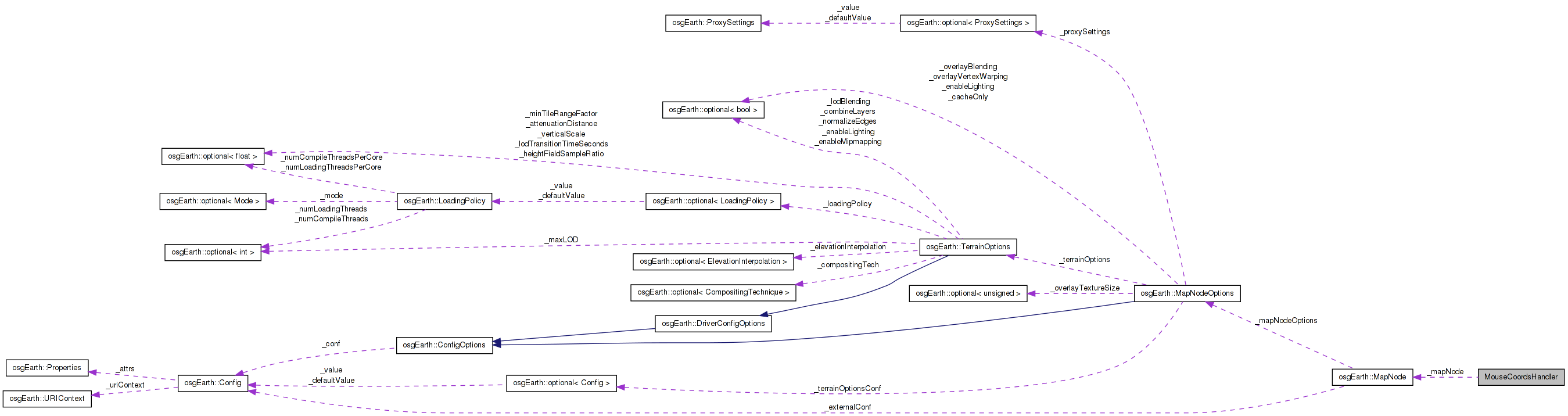
 Collaboration diagram for MouseCoordsHandler:
Public Member Functions | |
| MouseCoordsHandler (LabelControl *label, osgEarth::MapNode *mapNode) | |
| bool | handle (const osgGA::GUIEventAdapter &ea, osgGA::GUIActionAdapter &aa) |
Public Attributes | |
| osg::ref_ptr< LabelControl > | _label |
| MapNode * | _mapNode |
| osg::NodePath | _mapNodePath |
Definition at line 98 of file osgearth_viewer.cpp.
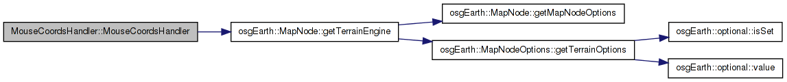
| MouseCoordsHandler::MouseCoordsHandler | ( | LabelControl * | label, |
| osgEarth::MapNode * | mapNode | ||
| ) | [inline] |
Definition at line 100 of file osgearth_viewer.cpp.
        : _label( label ),
          _mapNode( mapNode )
    {
        _mapNodePath.push_back( mapNode->getTerrainEngine() );
    }
Here is the call graph for this function:| bool MouseCoordsHandler::handle | ( | const osgGA::GUIEventAdapter & | ea, |
| osgGA::GUIActionAdapter & | aa | ||
| ) | [inline] |
Definition at line 107 of file osgearth_viewer.cpp.
    {
        osgViewer::View* view = static_cast<osgViewer::View*>(aa.asView());
        if (ea.getEventType() == ea.MOVE || ea.getEventType() == ea.DRAG)
        {
            osgUtil::LineSegmentIntersector::Intersections results;
            if ( view->computeIntersections( ea.getX(), ea.getY(), _mapNodePath, results ) )
            {
                // find the first hit under the mouse:
                osgUtil::LineSegmentIntersector::Intersection first = *(results.begin());
                osg::Vec3d point = first.getWorldIntersectPoint();
                osg::Vec3d lla;

                // transform it to map coordinates:
                _mapNode->getMap()->worldPointToMapPoint(point, lla);

                std::stringstream ss;

                if ( s_mgrs )
                {
                    MGRSFormatter f( MGRSFormatter::PRECISION_1M );
                    ss << "MGRS: " << f.format(lla.y(), lla.x()) << "   ";
                }
                 // lat/long
                {
                    LatLongFormatter::AngularFormat fFormat = s_dms?
                        LatLongFormatter::FORMAT_DEGREES_MINUTES_SECONDS :
                        LatLongFormatter::FORMAT_DECIMAL_DEGREES;

                    LatLongFormatter f( fFormat );

                    ss
                        << "Lat: " << f.format( Angular(lla.y(),Units::DEGREES), 4 ) << "  "
                        << "Lon: " << f.format( Angular(lla.x(),Units::DEGREES), 5 );
                }

                _label->setText( ss.str() );
            }
            else
            {
                //Clear the text
                _label->setText( "" );
            }
        }
        return false;
    }
Here is the call graph for this function:| osg::ref_ptr< LabelControl > MouseCoordsHandler::_label |
Definition at line 154 of file osgearth_viewer.cpp.
Definition at line 155 of file osgearth_viewer.cpp.
| osg::NodePath MouseCoordsHandler::_mapNodePath |
Definition at line 156 of file osgearth_viewer.cpp.
 1.7.3
1.7.3