|
osgEarth 2.1.1
|
|
osgEarth 2.1.1
|
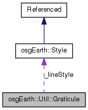
 Collaboration diagram for osgEarth::Util::Graticule:
Classes | |
| struct | Level |
Public Member Functions | |
| Graticule (const Map *map) | |
| void | setLineColor (const osg::Vec4f &value) |
| void | setTextColor (const osg::Vec4f &value) |
| void | addLevel (float maxRange, unsigned int cellsX, unsigned int cellsY, double lineWidth) |
Private Member Functions | |
| unsigned int | getID () const |
| bool | getLevel (unsigned int level, Graticule::Level &out_level) const |
| unsigned int | getNumLevels () const |
| osg::Node * | createGridLevel (unsigned int levelNum) const |
| osg::Node * | createTextLevel (unsigned int levelNum) const |
Private Attributes | |
| unsigned int | _id |
| bool | _autoLevels |
| osg::observer_ptr< const Map > | _map |
| std::vector< Level > | _levels |
| osg::Vec4f | _textColor |
| Style | _lineStyle |
Friends | |
| class | GraticuleFactory |
Implements a map graticule.
NOTE: So far, this only works for geocentric maps. TODO: Add projected support; add text label support
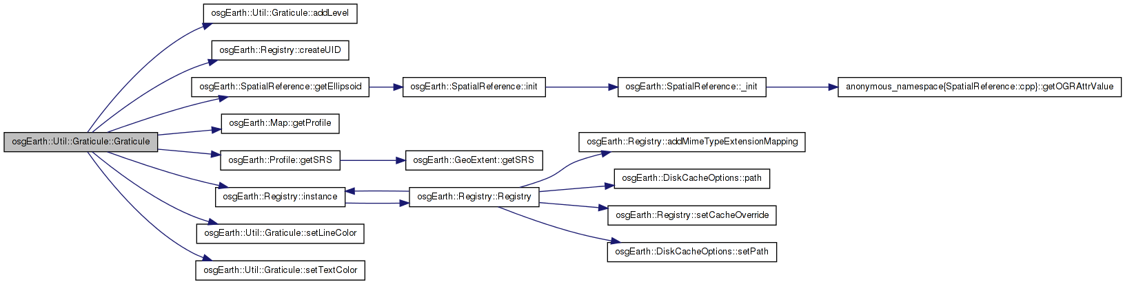
| Graticule::Graticule | ( | const Map * | map | ) |
Constructs a new graticule for use with the specified map. The graticule is created with several default levels. If you call addLevel(), the default levels are deleted.
| map | Map with which you will use this graticule |
Definition at line 80 of file Graticule.cpp.
                                     :
_autoLevels( true ),
_map( map ),
_textColor( 1,1,0,1 )
{
    // safely generate a unique ID for this graticule:
    _id = Registry::instance()->createUID();
    {
        ScopedLock<Mutex> lock( s_graticuleMutex );
        s_graticuleRegistry[_id] = this;
    }

    setLineColor( osg::Vec4f(1,1,1,0.7) );
    setTextColor( osg::Vec4f(1,1,0,1) );

    if ( _map->isGeocentric() )
    {
        double r = map->getProfile()->getSRS()->getEllipsoid()->getRadiusEquator();

        int x=8, y=4;
        double d = 3.5*r;
        double lw=0.15;
        addLevel( FLT_MAX, x, y, lw );
        for(int i=0; i<9; i++)
        {
            x *= 2, y *= 2;
            lw *= 0.5;
            d *= 0.5;
            addLevel( r+d, x, y, lw );
        }
    }

    // Prime the grid:
    {
        std::stringstream buf;
        buf << "0_" << _id << "." << GRID_MARKER << "." << GRATICLE_EXTENSION;
        std::string bufStr = buf.str();
        osg::ProxyNode* proxy = new osg::ProxyNode();
        proxy->setFileName( 0, bufStr );
        proxy->setCenterMode( osg::ProxyNode::USER_DEFINED_CENTER );
        proxy->setCenter( osg::Vec3(0,0,0) );
        proxy->setRadius( 1e10 );
        this->addChild( proxy );
    }

    // Prime the text:
    {
        std::stringstream buf;
        buf << "0_" << _id << "." << TEXT_MARKER << "." << GRATICLE_EXTENSION;
        std::string bufStr = buf.str();

        osg::ProxyNode* proxy = new osg::ProxyNode();
        proxy->setFileName( 0, bufStr );
        proxy->setCenterMode( osg::ProxyNode::USER_DEFINED_CENTER );
        proxy->setCenter( osg::Vec3(0,0,0) );
        proxy->setRadius( 1e10 );

        this->addChild( proxy );
    }

    osg::StateSet* set = this->getOrCreateStateSet();
    set->setRenderBinDetails( 9999, "RenderBin" );
    set->setAttributeAndModes(
        new osg::Depth( osg::Depth::ALWAYS ),
        osg::StateAttribute::ON | osg::StateAttribute::PROTECTED );
    set->setMode( GL_LIGHTING, 0 );

    //osg::Program* program = new osg::Program();
    //program->addShader( new osg::Shader( osg::Shader::VERTEX, s_vertexShader ) );
    //program->addShader( new osg::Shader( osg::Shader::FRAGMENT, s_fragmentShader ) );
    //set->setAttributeAndModes( program, osg::StateAttribute::ON );

    this->addEventCallback( new AutoClipPlaneCallback( _map.get() ) );
}
Here is the call graph for this function:| void Graticule::addLevel | ( | float | maxRange, |
| unsigned int | cellsX, | ||
| unsigned int | cellsY, | ||
| double | lineWidth | ||
| ) |
Adds a new level to the profile. Levels are sorted by maxRange. Calling this method deletes any automatically created default levels.
| maxRange | Maximum camera range for this level. |
| cellsX,cellsY | Number of grid cells in each direction at this level. |
| lineWidth | Width of the grid lines, in map units, at this level. |
Definition at line 156 of file Graticule.cpp.
{
    if ( _autoLevels )
    {
        _autoLevels = false;
        _levels.clear();
    }

    Level level;
    level._maxRange = maxRange;
    level._cellsX = cellsX;
    level._cellsY = cellsY;
    level._lineWidth = lineWidth;

    for( std::vector<Level>::iterator i = _levels.begin(); i != _levels.end(); ++i )
    {
        if ( maxRange > i->_maxRange )
        {
            _levels.insert( i, level );
            return;
        }
    }
    _levels.push_back( level );
}
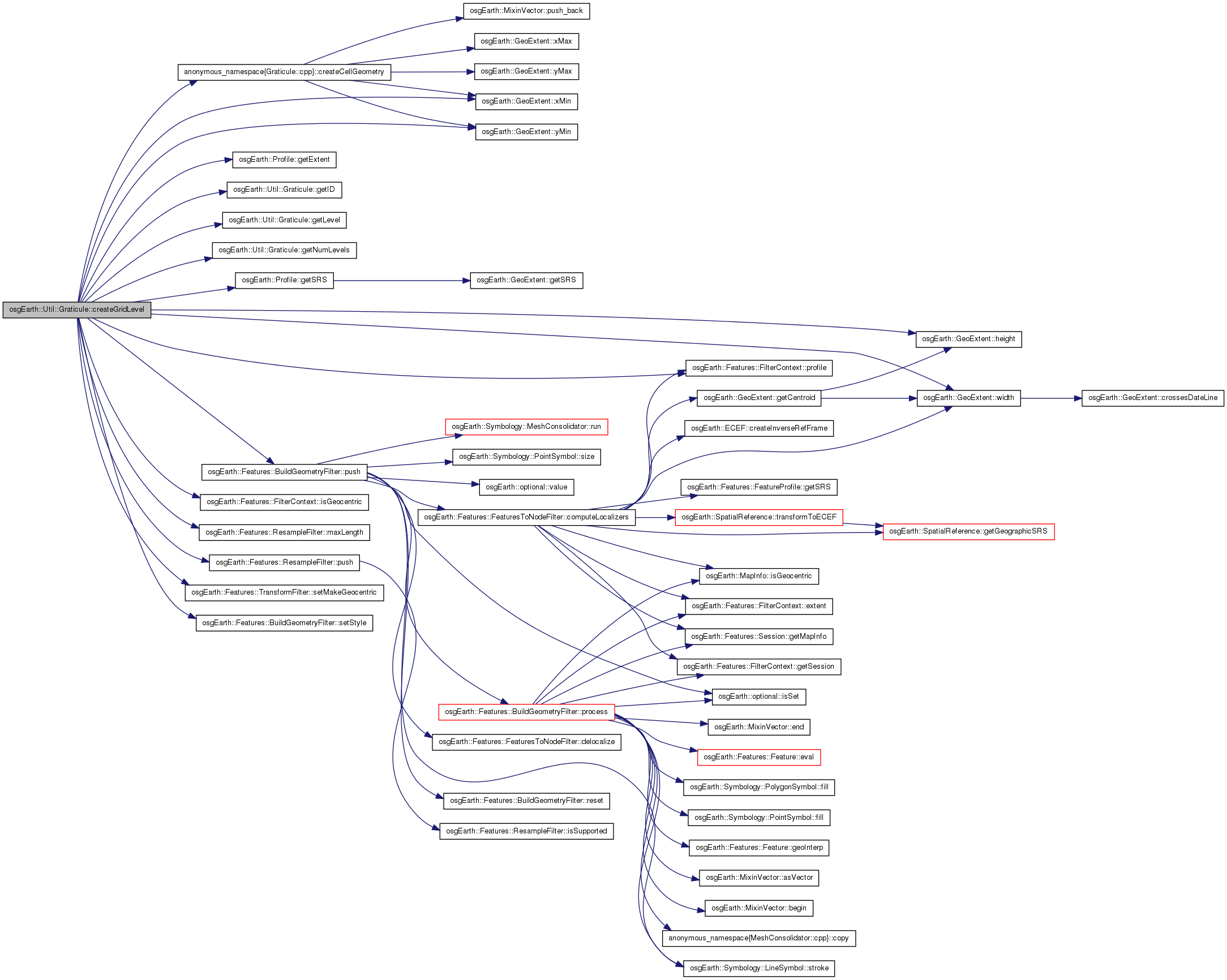
Here is the caller graph for this function:| osg::Node * Graticule::createGridLevel | ( | unsigned int | levelNum | ) | const [private] |
Definition at line 293 of file Graticule.cpp.
{
    if ( !_map->isGeocentric() )
    {
        OE_WARN << "Graticule: only supports geocentric maps" << std::endl;
        return 0L;
    }

    Graticule::Level level;
    if ( !getLevel( levelNum, level ) )
        return 0L;

    OE_DEBUG << "Graticule: creating grid level " << levelNum << std::endl;

    osg::Group* group = new osg::Group();

    const Profile* mapProfile = _map->getProfile();
    const GeoExtent& pex = mapProfile->getExtent();

    double tw = pex.width() / (double)level._cellsX;
    double th = pex.height() / (double)level._cellsY;

    for( unsigned int x=0; x<level._cellsX; ++x )
    {
        for( unsigned int y=0; y<level._cellsY; ++y )
        {
            GeoExtent tex(
                mapProfile->getSRS(),
                pex.xMin() + tw * (double)x,
                pex.yMin() + th * (double)y,
                pex.xMin() + tw * (double)(x+1),
                pex.yMin() + th * (double)(y+1) );

            Geometry* geom = createCellGeometry( tex, level._lineWidth, pex, _map->isGeocentric() );

            Feature* feature = new Feature();
            feature->setGeometry( geom );
            FeatureList features;
            features.push_back( feature );

            FilterContext cx;
            cx.profile() = new FeatureProfile( tex );
            cx.isGeocentric() = _map->isGeocentric();

            if ( _map->isGeocentric() )
            {
                // We need to make sure that on a round globe, the points are sampled such that
                // long segments follow the curvature of the earth.
                ResampleFilter resample;
                resample.maxLength() = tex.width() / 10.0;
                cx = resample.push( features, cx );
            }

            TransformFilter xform( mapProfile->getSRS() );
            xform.setMakeGeocentric( _map->isGeocentric() );
            xform.setLocalizeCoordinates( true );
            cx = xform.push( features, cx );

            osg::ref_ptr<osg::Node> output;
            BuildGeometryFilter bg;
            bg.setStyle( _lineStyle );
            //cx = bg.push( features, cx );
            output = bg.push( features, cx ); //.getNode();

            if ( cx.isGeocentric() )
            {
                // get the geocentric control point:
                double cplon, cplat, cpx, cpy, cpz;
                tex.getCentroid( cplon, cplat );
                tex.getSRS()->getEllipsoid()->convertLatLongHeightToXYZ(
                    osg::DegreesToRadians( cplat ), osg::DegreesToRadians( cplon ), 0.0, cpx, cpy, cpz );
                osg::Vec3 controlPoint(cpx, cpy, cpz);

                // get the horizon point:
                tex.getSRS()->getEllipsoid()->convertLatLongHeightToXYZ(
                    osg::DegreesToRadians( tex.yMin() ), osg::DegreesToRadians( tex.xMin() ), 0.0,
                    cpx, cpy, cpz );
                osg::Vec3 horizonPoint(cpx, cpy, cpz);

                // the deviation is the dot product of the control vector and the vector from the
                // control point to the horizon point.
                osg::Vec3 controlPointNorm = controlPoint; controlPointNorm.normalize();
                osg::Vec3 horizonVecNorm = horizonPoint - controlPoint; horizonVecNorm.normalize();
                float deviation = controlPointNorm * horizonVecNorm;

                // construct the culling callback using the deviation.
                osg::ClusterCullingCallback* ccc = new osg::ClusterCullingCallback();
                ccc->set( controlPoint, controlPointNorm, deviation, (controlPoint-horizonPoint).length() );

                // need a new group, because never put a cluster culler on a matrixtransform (doesn't work)
                osg::Group* me = new osg::Group();
                me->setCullCallback( ccc );
                me->addChild( output.get() );
                output = me;
            }

            group->addChild( output.get() );
        }
    }

    // organize it for better culling
    osgUtil::Optimizer opt;
    opt.optimize( group, osgUtil::Optimizer::SPATIALIZE_GROUPS );

    osg::Node* result = group;

    if ( levelNum < getNumLevels() )
    {
        Graticule::Level nextLevel;
        if ( getLevel( levelNum+1, nextLevel ) )
        {
            osg::PagedLOD* plod = new osg::PagedLOD();
            plod->addChild( group, nextLevel._maxRange, level._maxRange );
            std::stringstream buf;
            buf << levelNum+1 << "_" << getID() << "." << GRID_MARKER << "." << GRATICLE_EXTENSION;
            std::string bufStr = buf.str();
            plod->setFileName( 1, bufStr );
            plod->setRange( 1, 0, nextLevel._maxRange );
            result = plod;
        }
    }

    return result;
}
Here is the call graph for this function:| osg::Node * Graticule::createTextLevel | ( | unsigned int | levelNum | ) | const [private] |
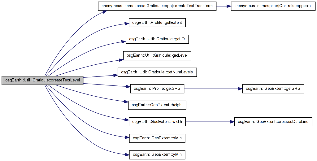
Definition at line 419 of file Graticule.cpp.
{
    if ( !_map->isGeocentric() )
    {
        OE_WARN << "Graticule: only supports geocentric maps" << std::endl;
        return 0L;
    }

    Graticule::Level level;
    if ( !getLevel( levelNum, level ) )
        return 0L;

    OE_DEBUG << "Graticule: creating text level " << levelNum << std::endl;

    osg::Group* group = new osg::Group();

    const Profile* mapProfile = _map->getProfile();
    const GeoExtent& pex = mapProfile->getExtent();

    double tw = pex.width() / (double)level._cellsX;
    double th = pex.height() / (double)level._cellsY;

    const osg::EllipsoidModel* ell = _map->getProfile()->getSRS()->getEllipsoid();

    for( unsigned int x=0; x<level._cellsX; ++x )
    {
        for( unsigned int y=0; y<level._cellsY; ++y )
        {
            GeoExtent tex(
                mapProfile->getSRS(),
                pex.xMin() + tw * (double)x,
                pex.yMin() + th * (double)y,
                pex.xMin() + tw * (double)(x+1),
                pex.yMin() + th * (double)(y+1) );

            double offset = 2.0 * level._lineWidth;

            double cx, cy;
            tex.getCentroid( cx, cy );

            // y value on the x-axis:
            group->addChild( createTextTransform(
                cx,
                tex.yMin() + offset,
                tex.yMin(),
                ell,
                20.0f,
                _textColor ) );

            // x value on the y-axis:
            group->addChild( createTextTransform(
                tex.xMin() + offset,
                cy,
                tex.xMin(),
                ell,
                20.0f,
                _textColor,
                -90.0f ) );
        }
    }

    // organize it for better culling
    osgUtil::Optimizer opt;
    opt.optimize( group, osgUtil::Optimizer::SPATIALIZE_GROUPS );

    osg::Node* result = group;

    if ( levelNum+1 < getNumLevels() )
    {
        Graticule::Level nextLevel;
        if ( getLevel( levelNum+1, nextLevel ) )
        {
            osg::PagedLOD* plod = new osg::PagedLOD();
            plod->addChild( group, nextLevel._maxRange, level._maxRange );
            std::stringstream buf;
            buf << levelNum+1 << "_" << getID() << "." << TEXT_MARKER << "." << GRATICLE_EXTENSION;
            std::string bufStr = buf.str();
            plod->setFileName( 1, bufStr );
            plod->setRange( 1, 0, nextLevel._maxRange );
            result = plod;
        }
    }
    return result;
}
Here is the call graph for this function:| unsigned int osgEarth::Util::Graticule::getID | ( | ) | const [inline, private] |
| bool Graticule::getLevel | ( | unsigned int | level, |
| Graticule::Level & | out_level | ||
| ) | const [private] |
Definition at line 182 of file Graticule.cpp.
{
    if ( level < _levels.size() )
    {
        out_level = _levels[level];
        return true;
    }
    else
    {
        return false;
    }
}
Here is the caller graph for this function:| unsigned int osgEarth::Util::Graticule::getNumLevels | ( | ) | const [inline, private] |
| void Graticule::setLineColor | ( | const osg::Vec4f & | value | ) |
Sets the color of the grid lines
Definition at line 287 of file Graticule.cpp.
{
    _lineStyle.getOrCreateSymbol<LineSymbol>()->stroke()->color() = color;
}
Here is the caller graph for this function:| void osgEarth::Util::Graticule::setTextColor | ( | const osg::Vec4f & | value | ) | [inline] |
Sets the color of the text labels
Definition at line 60 of file Graticule.
{ _textColor = value; }
Here is the caller graph for this function:friend class GraticuleFactory [friend] |
bool osgEarth::Util::Graticule::_autoLevels [private] |
unsigned int osgEarth::Util::Graticule::_id [private] |
std::vector<Level> osgEarth::Util::Graticule::_levels [private] |
Style osgEarth::Util::Graticule::_lineStyle [private] |
osg::observer_ptr<const Map> osgEarth::Util::Graticule::_map [private] |
osg::Vec4f osgEarth::Util::Graticule::_textColor [private] |
 1.7.3
1.7.3